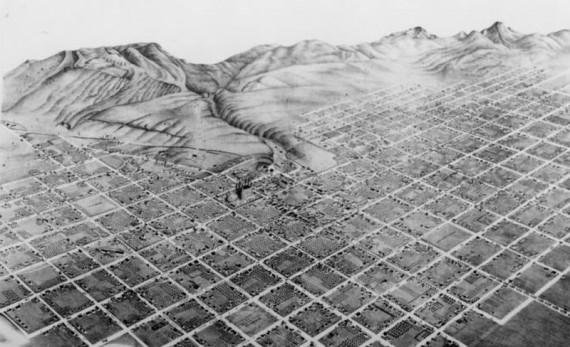
If you take a stroll around any city block in downtown Salt Lake, expect that the trip will take much longer than it would to circle a block in any other state. This is due to the fact that Salt Lake City has the largest city blocks in the United States. The early settlers in the Utah valley weren’t trying to win a competition; they were simply following a plan to accommodate their agricultural and lifestyle needs. In fact, the plan for the area’s layout was conceived long before the pioneers even arrived in Utah.
The plan for the town was developed by Joseph Smith, founder of The Church of Jesus Christ of Latter Day Saints. Smith’s plan called for each community to be laid out in a square grid pattern, with sufficient land for each family of settlers to have their own home, orchard, and garden. Joseph Smith never lived in the Salt Lake Valley. Nevertheless, his plan for the City of Zion (called the Plat of Zion) was carried out by the early pioneers who settled the land. The grid plan called for the area to be developed in symmetrical 7 x 7 blocks with wide streets.
The city was laid out in a series of plats with the original being Plat A. This plat was laid out with 135 10-acre blocks. The blocks were numbered sequentially with block 1 starting at the corner of 300 West and 900 South. As the territory grew, more blocks were added to the grid. In addition to the block numbering system, settlers had simplicity and convenience in mind when they set up the numbering system and addresses. The addresses on the north and east sides of the streets use even numbers and those on the west and south sides use odd numbers.
The development of each block within the entire grid was proof of the effective planning that went into settling the valley. The houses on the blocks were positioned up front with a garden and barn in the back. No house on any of the blocks faced each other. This gave the home owners a feeling of spaciousness and privacy and exhibited a level practicality. Due to the limited water resources flowing into the area from small streams, this grid pattern created a much more feasible set up for irrigation. Also, settlers found that it was much more convenient to have their barns and domestic animals near their homes instead of outside the city limits.
Within the blocks there was space for public squares that included churches, schools, and other community buildings. Evidence of the original “public squares” exists today which includes Temple Square, the Old Fort (Pioneer Park), the city/county building (Washington Square) and the University of Deseret/Utah (now West High School).
Before the pioneers moved west, they experimented with the block-type settlement in Ohio, Missouri, and Illinois. But the topography of Utah’s Great Basin adapted well to the grid structure.
The early settlements had a rich social and cultural atmosphere. One of the early pioneer leaders, Brigham Young, recognized that the area’s agriculture was strong. Their crops and fruit trees were flourishing and the settlers maintained a strong sense of community. This type of environment was important; therefore, there was no urgency to develop into a commerce-based society.
Many other cities throughout the United States designed their cities based on European styles. But Utah sports the country’s only home-grown layout and has received national recognition for its originality in city planning and development.
By Salt Lake Digs Contributor, David Jensen
Digital Image © 2009 Utah State Historical Society. All Rights Reserved.